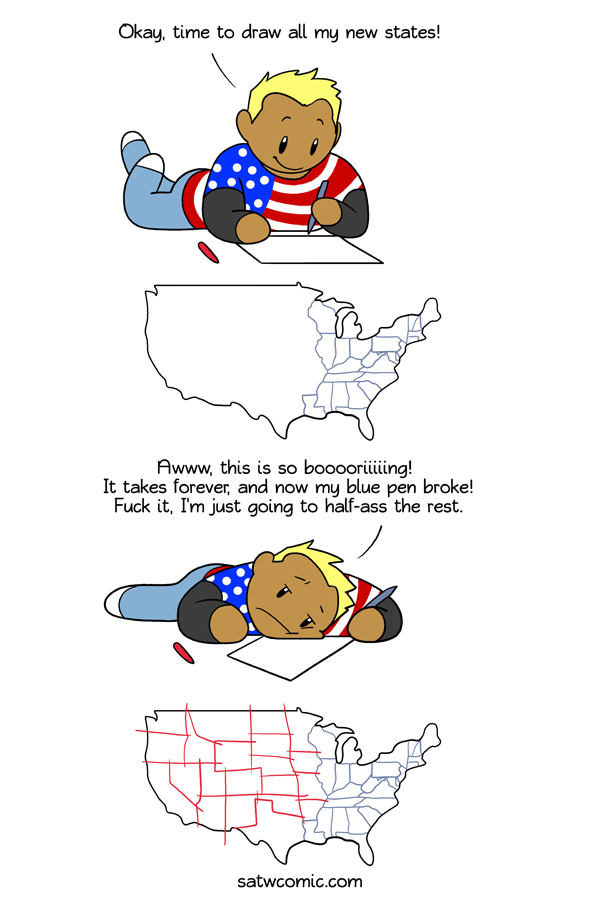
That'll have to do
I was asked if I ever noticed how small and squiggly-lined the states in the East are compared to the huge mostly straight-lined states in the rest of the country.
America
13th July 2018
Hfar


8 years ago #9778257
13
0
That's because in the east the state lines were defined by silly things like pre-independence international borders, social-economic centers, and complex interstate politics. While the west basically boiled down to "We have a shit ton of new land now and we need to divide it somehow. Fuck it! Squares are easy to manage! Squares for everyone!"
8 years ago #9778580
8
0
The borders of the eastern states (and some states in the west like Oregon) follow natural boundaries like rivers and mountain chains. As we moved west, the states were cut up into squarish shapes because it made it easier for the US government to cut it up into square parcels for homesteaders.
8 years ago #9778553
8
2
As an American, I can confirm that this is false. Truth, they're ALL half-assed.
8 years ago #9778409
7
0
A joke that works both in comparing Europe to the US, and (in this case Eastern US to Western US)...
In the East, 100 miles is a long distance. In the West 100 years is a long time.
Also bear in mind that when the eastern states were established, transportation was limited to feet, horses, and sail. For much of the western states, railroads and steamships, plus telegraph. Speed of transportation and communication has a lot to do with are of control.
8 years ago #9778284
6
0
I live in Washington and one of my friends who lives in New England came to visit a while back. We went on a road trip to east of the Cascade mountains and he asked at the end how many states we had passed through and was shocked when I said that we hadn't even left the one we were in, since most of the states in New England are so small compared to western states.
8 years ago #9778265
6
0
Chinese originality with province names: North Lake, South Lake (Hu Bei and Hu Nan); North River, South River (He Bei and He Nan); Mountain West, Mountain East (Shan Dong and Shan Xi) and Guang Dong and Guang Xi.
We also have the cities of North Capital (Beijing), South Capital (Nanjing), East Capital (Tokyo, in Japan) and West Capital (one of the other names of Chang’an (Xi’an)).
We also have the cities of North Capital (Beijing), South Capital (Nanjing), East Capital (Tokyo, in Japan) and West Capital (one of the other names of Chang’an (Xi’an)).
8 years ago #9778242
6
0
As a native of the western states I can tell you this: There may be a lot of land there, but there's not a lot of people. This is a map of states sized by population density (https://matadornetwork.com/read/mapped-us-states-scaled-proportionally-population-density/) It's modern, but it still gives you the idea.
8 years ago #9778519
5
0
Yo listen up, here's the story
About a little guy that lives in a square world
And all day and all night and everything he sees is just square
Like him, inside and outside
Square his house with a square little window
And a square Honda
And everything is square for him
because he lives in Nebraska. he being me. He's square, da ba dee da ba daa
8 years ago #9778991
4
0
States in the east, many of them established before detailed surveys had been done, were often set up using rivers as easily defined natural borders. States in the west were laid out much later when it was easier to draw a line on an existing map of the area.
Add comment: Please Sign in or create an accout to comment.


 Support the comic on


